Yellowstone Project

Figure 1: Overview of Yellowstone Property - Mustang Energy (1), (4), (7), (8)
Highlights
-
Ownership: 100% owned by Mustang Energy
-
Size: 21,820 hectares across 7 contiguous claims.
-
Location:
-
Approximately 16 km west of the historic Cluff Lake Mine which produced over 62 million pounds of uranium U3O8 at an average grade of 0.9%. (2)
-
Approximately 20 km northwest of the Shea Creek Deposit (jointly held by Orano Canada Inc. and UEX Corp.), with an NI 43-101 compliant indicated resource of 67.57 million pounds of U3O8 at an average grade of 1.49%. (3)
-
Adjacent to Fission Uranium’s West Cluff Project and surrounding the Carswell Impact Structure.
-
-
Geological Potential:
-
Historical data highlights multiple conductive anomalies and fault zones possibly associated with uranium mineralization. (4), (5)
-
-
Previous Work:
-
Extensive geophysical datasets, including ZTEM (2011) (4), VTEM (2010) (6), and MEGATEM (2007) (7), reveal high-priority exploration targets, such as prospective NE-SW fault zones that are analogous to the structural setting of the Cluff Lake Deposit and numerous conductive corridors.
-
Targets
1. Sylvia Lake Area (Priority 1):
-
Located outside the Carswell Structure, this area has minimal structural complexity, making it ideal for traditional EM methods.
-
Identified as Priority 1 Zone for follow-up exploration by Can Alaska in 2011 ZTEM Report (SMAD# 74K05-0147). (4)
-
Conductive NE-SW regional fault structure associated with the Banana Lake Uranium Zone (SMDI 2729) approximately 16 km NE (Figure 2). (5)
-
Diabase dyke complex and a magnetic low cross-cut by the Harrison Fault structure which offers a similar structural setting to the Shea Creek deposit ~20 km SE (Figure 3).

Figure 2: Sylvia Lake Target 1 with ZTEM underlay (1), (4)
Exploration Plan (Next Steps)
1. Data Refinement:
-
Reprocess historical ZTEM, VTEM, MEGATEM, GEOTEM, and ground EM datasets to refine anomalies and validate targets.
2. Geophysical Surveys:
-
Complete MobileMTTM high-resolution EM survey in the northern project area that was previously missed by 2010-2011 VTEM and ZTEM surveys targeting deep conductors identified in ZTEM data.
-
Image deep conductors possibly associated with unconformity or basement-hosted uranium mineralization.
3. Drilling:
-
Initiate maiden drill program of high-priority targets in the Sylvia Lake region and NE project area focusing on key conductors and fault intersections.
1. Carswell West (Priority 1):
-
The inner ring of the Carswell Structure is crosscut by NE-SW faults associated with nearby mineralization at Cluff Lake and Shea Creek.
-
ZTEM data highlights shallow conductive anomalies near the central uplift and deeper anomalies warranting ground-based EM follow-up. (4)
-
Prospective zones include areas adjacent to NE-SW faults and mapped basement faults (Figure 4).
-
Radiometric anomaly with a similar signature to Cluff Lake Mine (Figure 4).

Figure 4: Yellowstone project overview map with radiometrics underlay
References
(1) Saskatchewan GeoAtlas, Retrieved from https://gisappl.saskatchewan.ca/Html5Ext/index.html?viewer=GeoAtlas
(2) Cluff Lake Mine Uranium Production – Orano: Retrieved from https://www.orano.group/canada/en/news-resources/news/2023/may/cluff-lake-project-concludes-mining-life-cycle
(3) Shea Creek. Uranium Energy Corp. Retrieved from https://www.uraniumenergy.com/projects/canada/shea-creek/
(4) Saskatchewan Mineral Assessment Database, SMAD# 74K05-0147, 2011 ZTEM, Retrieved from http://mineral-assessment.saskatchewan.ca/Pages/BasePages/Main.aspx
(5) Saskatchewan Mineral Deposits Index. (n.d.). Banana Lake Uranium Zone or Drill Holes BAN-7 and -8). Retrieved from https://mineraldeposits.saskatchewan.ca/Home/Viewdetails/2729
(6) Saskatchewan Mineral Assessment Database, SMAD# 74K05-0145_2010 CanAlaska VTEM, Retrieved from http://mineral-assessment.saskatchewan.ca/Pages/BasePages/Main.aspx
(7) Saskatchewan Mineral Assessment Database, SMAD# 74K06-0088_2007_MEGATEM_Lithogeochem, Retrieved from http://mineral-assessment.saskatchewan.ca/Pages/BasePages/Main.aspx
(8) Saskatchewan Mineral Assessment Database, SMAD# 74K05-0140, Drill hole SYL-1, Sylia Lake Project 1998 Activities and Results, Retrieved from http://mineral-assessment.saskatchewan.ca/Pages/BasePages/Main.aspx
1. Priority 2 and 3 Zones:
-
Areas with deeper basement (>700m) or multiple overlying conductive sedimentary units, such as Douglas and Wolverine Point formations, which may screen basement conductors, are lower priority for exploration.
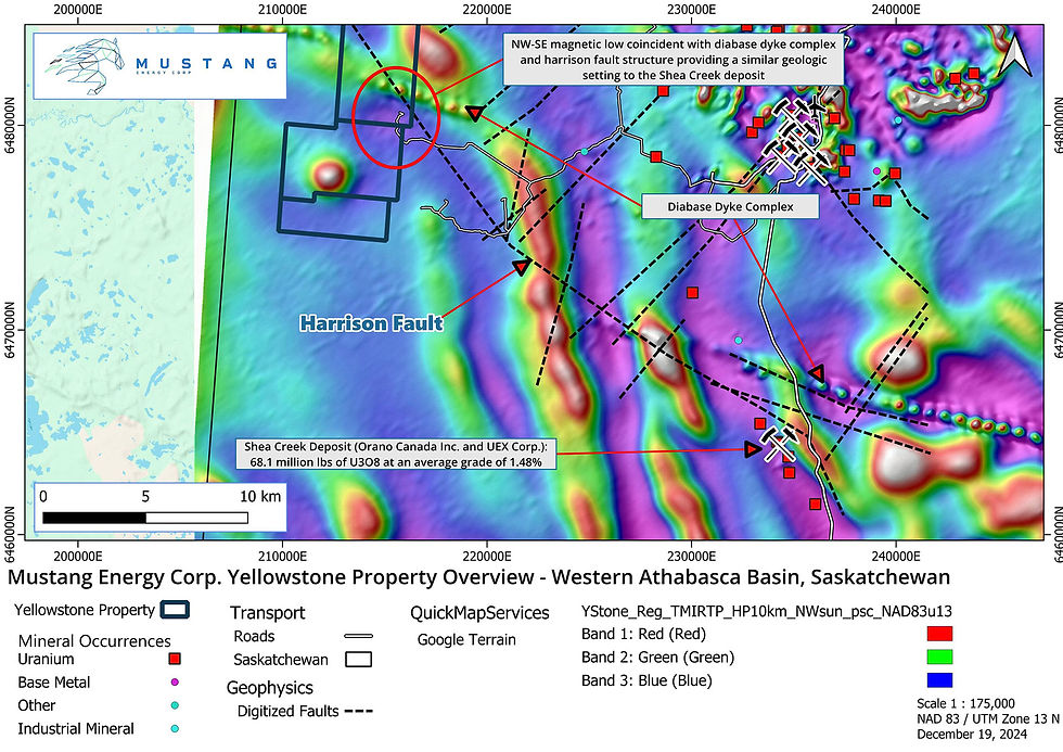
Figure 3: Sylvia Lake Target 2 with total magnetic intensity underlay (1)